Immediate Vault Immediate Access

Amid Wildfires, California’s Emergency Warning Systems Take Heat

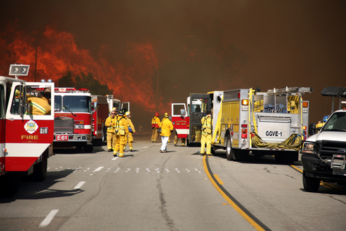
Overnight, the Mendocino Complex Fire in Northern California expanded far enough to oust the 2017 Thomas Fire as the largest wildfire in the state’s history. Comprising two joined fires, the Mendocino Complex Fire has burned through 443 square miles in the area north of San Francisco. As of Tuesday morning, the fires burned more than 140 structures, including at least 75 homes, and was 30% contained.

But California’s residents and businesses still should be on alert, as the incendiary activity doesn’t end there. An unprecedented 14,000 firefighters are combating between 12 and 16 wildfires in the state, according to the Department of Forestry and Fire Protection. Particular emphasis is in Northern California, where the fires in Mariposa and Shasta counties continue to threaten residents, businesses, and emergency responders. For 26 days, the Ferguson Fire in Mariposa County has burned nearly 90,000 acres and caused two fatalities. The fire is having a huge impact on areas near and around Yosemite National Park, which alerted the public that it had closed all but two entrances and roads.

Redding, a city 150 miles north of Sacramento, is the site of the Carr Fire, which has been ablaze for two weeks. Weather.com reported that the fire has caused seven deaths and the destruction of nearly 1,600 structures, the majority of which are homes.

The city of Redding launched an interactive map that provides residents with images of neighborhoods so they can check the status of their homes. Reports indicate that more than 1,800 structures are still in the path of the fire.

Despite such technological advances, many residents have questioned the effectiveness of the state’s emergency notification system, which they rely on for evacuation notices. The California Governor’s Office of Emergency Services currently uses an integrated California Public Alert and Warning System (CalPAWS) Plan to warn the public of danger.

Affected residents in several areas have claimed that they did not receive the CalPAWS evacuation order – including the great-grandmother who perished in the Carr fire in July with her two great-grandchildren. On Aug. 4, California Gov. Jerry Brown held a press conference in Shasta County to discuss the damage. But California’s emergency notification systems—and its unreliability in certain areas of the state—were a central focus of the conference.

Gov. Brown said he would consider legislation to improve alert systems, acknowledging local lawmakers’ proposals in an effort to create a statewide system that requires registration from all residents.

“I think we do need the best alert system we can get, and that’s what I would help the Legislature achieve,” Brown said, according to the Sacramento Bee. “There’s a lot of things we can do, and we can always do more … given the rising threats on the changing of the weather, the climate.”

The Bee reported that a bill with adoption plans for a uniform alert system has been drafted:

The bill, Senate Bill 833, would require counties to automatically sign up residents for a uniform cell phone alert system. It would also fund a standardized system equipped to push out alerts on all forms of media—radio, television, electronic highway billboards and landlines. County emergency managers would be required to undergo annual training on the latest alert technology.

Under such a plan, which would utilize the federal Wireless Emergency Alerts system, they’d have to opt out rather than sign up voluntarily.

Furthermore, the governor said he hopes to overhaul the state’s 911 system, which would de-centralize the calls and notifications to ensure more accurate messaging.

Also on Aug. 4, the White House approved California’s request for a Presidential Major Disaster Declaration to help with the impacts of the wildfire in Shasta County.

“This is part of a trenda new normalthat we’ve got to deal with. We’re dealing with it humanly, financially and governmentally,” Gov. Brown said during a media briefing at the Carr Fire Incident Command Post in Anderson, California. “These kinds of horrible situations bring people together, regardless of the lesser kind of ideologies and partisan considerations.”

Casualties Mount as Calif. Fire Continues to Burn

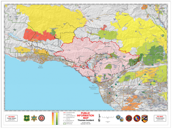
The massive Thomas Fire in Ventura County has claimed another victim. CalFire Engineer Cory Iverson was killed while battling the blaze, which has so far burned 252,500 acres and destroyed about 1,000 homes and businesses, according to the federal InciWeb fire information website. One other death connected to the fire was a woman killed in a car crash while evacuating.
Iverson had been with the agency since 2009 and was assigned to the Thomas Fire as part of a fire-engine strike team from CalFire’s San Diego unit.

“I know I speak for us all in saying our hearts go out to our CalFire colleagues during this difficult time.

buy lexapro online bristolrehabclinic.ca/wp-content/uploads/2023/10/jpg/lexapro.html no prescription pharmacy

This is a tragic reminder of the dangerous work that our firefighters do every day,” Teresa Benson forest supervisor, Los Padres National Forest said in a statement. “The Thomas Fire has many unprecedented conditions and complexities that challenge the already demanding job of fire suppression.”

The Thomas fire broke out Dec. 4 in Ojai, northwest of Los Angeles. Strong Santa Ana winds helped it to quickly spread to the city of Ventura, according to InciWeb.

Up to 85,000 people were impacted by power outages and surges in the Santa Barbara area, according to the Southern California Edison utility company. Santa Ana winds are expected to continue on Friday and through the weekend, and could reach up to 30 miles per hour in some areas. Ventura County, northwest of Los Angeles, has ordered mandatory evacuation of a portion of the county.

The Thomas fire has also taken a toll on agriculture, which is a billion industry in California employing more than 400,000 people in the state.

buy stendra online healthdirectionsinc.com/flash/swf/stendra.html no prescription pharmacy

The wildfire struck the largest avocado- and lemon-producing region in the United States. A 200-acre farm lost 80% of its avocado crop, according to the New York Times. Avocado orchards are more vulnerable because of their location near hillsides in the path of the fire.

buy sildalis online bristolrehabclinic.ca/wp-content/uploads/2023/10/jpg/sildalis.html no prescription pharmacy

Consumers are unlikely to see a surge in the price of avocados from the fire because most avocados bought in the United States are grown in Mexico. A spike in lemon prices is unlikely to occur even though Ventura County produces more than 40% of the national output, because any lost crop can be made up by increasing imports, John Krist, chief executive of the Ventura County Farm Bureau told the Times.

Protecting Your Business from Wildfires

There are currently about 60 large wildfires burning in the United States, mostly in western states.

buy minocin online rxbio.com/images/milestones/jpg/minocin.html no prescription pharmacy

But a combination of high temperatures and dry and windy conditions can make wildfires a threat almost anywhere. Adding to the situation is the fact that more and more businesses are expanding into the wildland-urban interface (WUI)—wildfire-prone areas where homes and businesses are located. This creates a growing wildfire risk to businesses, according to the Insurance Institute for Business and Home Safety (IIBHS).

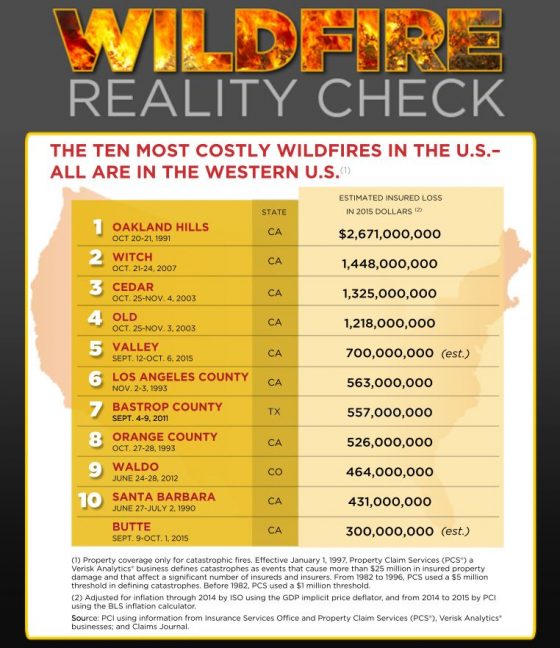
The Property Casualty Insurers Association of America lists the most expensive U.S. wildfires to date, all in western states:

To protect buildings from wildfires, IIBHS recommends that businesses survey the materials and design features of their structures; as well as the types of plants used, their location and maintenance.

Organizations also should determine their fire hazard severity zone (FHSZ) by evaluating the landscape, fire history in the area and terrain features such as slope of the land. Organizations can request the FHSZ rating from local building or fire officials in their area.

IIBHS notes three sources of wildfire ignition:

  1. Burning embers, or firebrands, generated by a wildfire and made worse in windy conditions.
    • Embers can ignite in several ways: By igniting combustible construction materials directly when accumulating on or immediately adjacent to them. Combustible construction materials are those that ignite and burn such as wood, plastic, and wood-plastic products used in decking and siding. By igniting nearby plants and accumulated debris such as pine needles or other combustible materials such as a wood pile.
      buy doxycycline online meadfamilydental.com/wp-content/uploads/2023/10/jpg/doxycycline.html no prescription pharmacy

      By entering a building through openings, such as an open window or attic vent, and ignite combustible items inside the building.
      buy valtrex online https://galenapharm.com/pharmacy/valtrex.html no prescription

  1. Direct flame contact from the wildfire
  2. Radiant heat emanating from the fire

It is critical to assess a building’s construction, including roofs, windows, vents and exterior walls, also important is the area surrounding a structure, including trees and plants, IIBHS said.

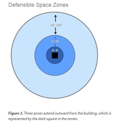
A defensible space zone around the building will reduce the risk of fire. This includes consideration of specific types of plants and how they are grouped and maintained.
buy ivermectin online rxbio.com/images/milestones/jpg/ivermectin.html no prescription pharmacy

Plant characteristics associated with higher combustibility include:

  • Narrow leaves or needles (often evergreen)
  • Volatile resins and oils, as indicated by leaves that have an aromatic odor when crushed
  • Accumulation of fine, twiggy, dry, or dead material on the plant or on the ground under the plant
  • Loose or papery bark that often falls off and accumulates on the ground (such as palms and eucalyptus).

Santa Barbara Fire: A Costly Disaster

Though the wildfire in Santa Barbara county has been mostly contained, damage estimates continue to rise. Authorities say 77 homes have been destroyed — nearly double what was originally estimated — in the affluent Southern California area of Jesusita.

The median home value for the Jesusita area is just over USD 500k, but it does contain a number of multi-million dollar mansions—several of which reportedly have been destroyed.

buy symbicort online blockdrugstores.com/wp-content/uploads/2023/10/jpg/symbicort.html no prescription pharmacy

Buildings in the area are constructed of stucco walls and chimney finishes, have shed (flat) roofs covered with low-pitched clay tile and terra cotta or cast-concrete ornaments. The homes generally have little cleared area separating them from the surrounding vegetation, which consists of an equal mix of chaparral, brush, and conifers. In many cases, even homes that do have partial setbacks will be affected by encroaching flames, depending on the direction of the fire and accompanying winds.

buy zoloft online blockdrugstores.com/wp-content/uploads/2023/10/jpg/zoloft.html no prescription pharmacy

The blaze is 65% contained and all but 375 residents from 145 homes had been allowed to move back in. Insured losses from this fire are expected to be large, but residents of California are no strangers to insurance claims resulting from wildfires. As the Insurance Information Institute reports:

Nine of the ten largest wildfires, in terms of insured property losses, occurred prior to 2007, according to ISO data. A 1991 wildfire in Oakland, California tops the list with $ $2,687 in insured losses in 2008 dollars. In October 2007 a series of wildfires broke out across Southern California, damaging thousands of homes and causing widespread evacuations.

buy vilitra online blockdrugstores.com/wp-content/uploads/2023/10/jpg/vilitra.html no prescription pharmacy

The largest of these fires, the October 21 Witch fire, resulted in 4 billion in insured losses and was the second most damaging wildfire since 1970, in 2008 dollars.

shutterstock_wildfire