Immediate Vault Immediate Access

Flood, Wind Dominant Natural Hazards in 2016

While most natural hazards occurring in the United States last year saw average or below average activity, the exceptions were flood and wind, according to the CoreLogic report Natural Hazard Risk Summary and Analysis, released today.

Severe flood events driven by substantial rainfall were the dominant natural hazards, with Louisiana and North Carolina floods being the major loss contributors. As in 2015, hurricanes and tropical storms in 2016 continued to cause inland flooding through increased and intense rainfall—even when not making landfall, according to the report.
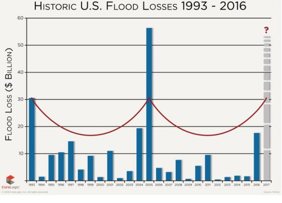
The National Oceanic and Atmospheric Administration (NOAA) said there were 12 individual weather and climate disaster events in the U.S. with losses exceeding $1 billion in 2016.

According to the report:

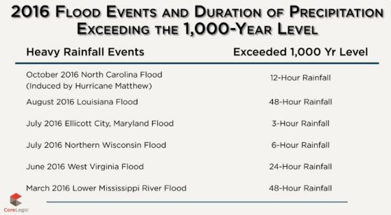
  • Based on NOAA and CoreLogic analysis, the overall flood loss in 2016, driven by six, 1,000-year plus rain events, was approximately $17 billion, which is six times greater than the overall flood damage experienced in 2015.
  • The U.S. Geological Survey (USGS) recorded 943 earthquakes of magnitude 3.0 or greater in 2016, with more than 60 percent of these earthquakes located in Oklahoma.
  • The National Interagency Fire Center (NIFC) reported a total of 5,415,121 acres burned from 62,864 separate fires in 2016.
    buy arimidex online achievephysiorehab.ca/wp-content/uploads/2023/10/jpg/arimidex.html no prescription pharmacy

    While the total acres burned in 2016 fell below the 10-year average, significant losses occurred, with thousands of homes in California and Tennessee destroyed by several smaller fires that burned in populated areas.

  • Wind activity in 2016 was slightly above average, due in large part to strong winds brought by Hurricane Matthew.
    buy mobic online achievephysiorehab.ca/wp-content/uploads/2023/10/jpg/mobic.html no prescription pharmacy

  • Hail activity in 2016 was near the average, and Texas experienced the worst of this natural hazard.
  • Tornado activity in 2016 was near average compared with previous years.
  • Hurricane Matthew developed late in the year and grew to a Category 5 storm, resulting in substantial damage along the southeastern seaboard.
  • There were below-average levels of tropical cyclone activity in the western North Pacific Basin encompassing East and Southeast Asia in 2016.

However, 2016 became known as the year without a winter. Nine winter storms impacted the U.S. in 2016, the most notable being the late-January winter storm in New York.

“History has continually shown us that it is impossible to determine exactly when or where the next wildfire, flood or earthquake will strike, which is why preparedness, response and post-loss assessment are paramount,” CoreLogic said.
Anticipating Hurricane Matthew, 4 States Declare Emergency

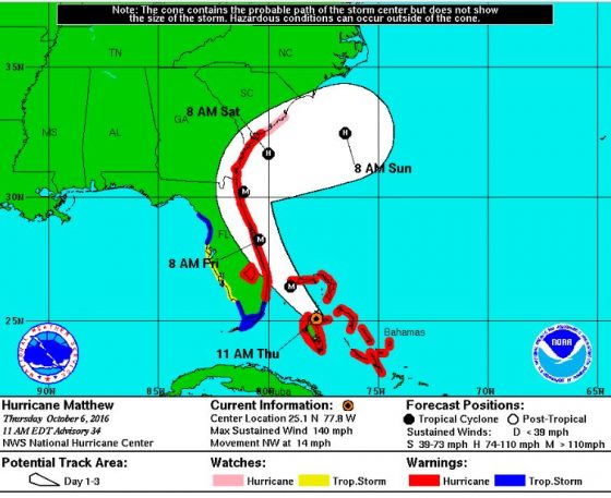
matthew-map
Rebounding to Category 4 hurricane classification, Matthew now has winds up to 140 miles per hour and has caused at least 28 deaths in three Caribbean countries. It is heading for the southeastern U.S., where four states—Florida, Georgia, South Carolina and North Carolina—have issued a state of emergency and evacuation orders in coastal regions.

Matthew was a Category 4 hurricane through Tuesday, was downgraded to a Category 3 early on Wednesday, and has now returned to Category 4 strength today, according to the U.S. National Hurricane Center (NHC).

Florida Gov. Rick Scott issued a warning on Thursday urging those in evacuation zones to leave immediately. “Based on the current forecast, the heights of storm surge will be above ground. Waves will be crashing on roofs. Homes will be destroyed,” he tweeted in both English and Spanish on Thursday morning.

“Time is up, Hurricane Matthew is approaching Florida. If you are in an evacuation zone, leave now,” he said in a statement. “To everyone on Florida’s east coast, if you are reluctant to evacuate, just think of all the people the hurricane has already killed.  You and your family could be among these numbers if you don’t take this seriously.”

Scott said that so far more than 4,000 National Guard members have been activated to help with evacuations and sheltering. He tweeted that as of 6:00 a.m., more than 3,000 people were in about 60 shelters. The state offers a mobile app to help those in flood-prone areas find the nearest shelter and also avoid traffic congestion.

A state of emergency has been declared by Georgia’s governor for 13 coastal counties. South Carolina’s governor declared a state of emergency and has begun coastal evacuations that may affect up to 1 million people. Because of heavy traffic, lane reversals on some highways are in effect, and schools and government offices in 25 South Carolina counties are closed today. North Carolina’s governor has declared a state of emergency for more than 50 counties and issued a mandatory evacuation order for Ocracoke Island, AIR Worldwide reported.

The Federal Emergency Management Agency (FEMA) has sent personnel and supplies to all four states, and President Obama is meeting with FEMA officials coordinating the response to Hurricane Matthew at the agency’s headquarters in Washington, D.C.

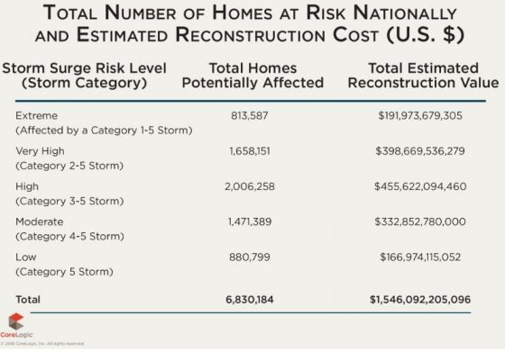
According to CoreLogic, a Category 3 storm hitting Miami could potentially damage 176,000 homes at a reconstruction cost value (RCV) of about $3.8 billion.

CoreLogic’s Storm Surge Risk Report estimates that more than 6.8 million homes located along the Gulf and Atlantic coasts are at risk of storm surge damage, with a total RCV of about $1.5 trillion.The length of coastline, coastal elevation and density of residential development all contribute to the risk of storm surge flooding.
core-logic-1

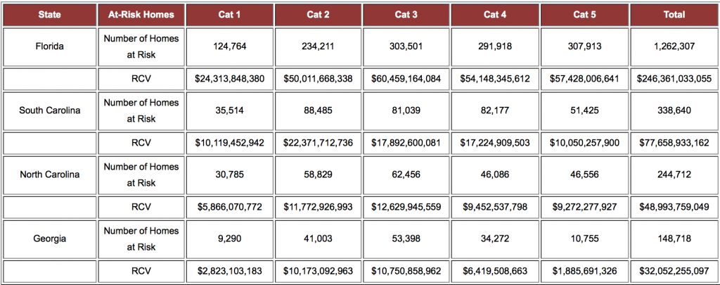
According to CoreLogic, the total number and total value of residential properties for the four states currently bracing for Hurricane Matthew are:

Total Number and Total Value of Residential Properties by State

Tool Calculates Natural Hazard Risk to Property

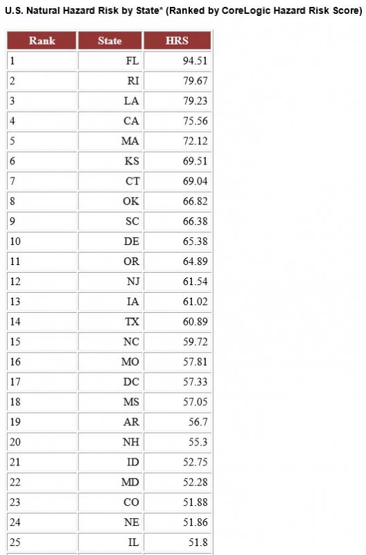
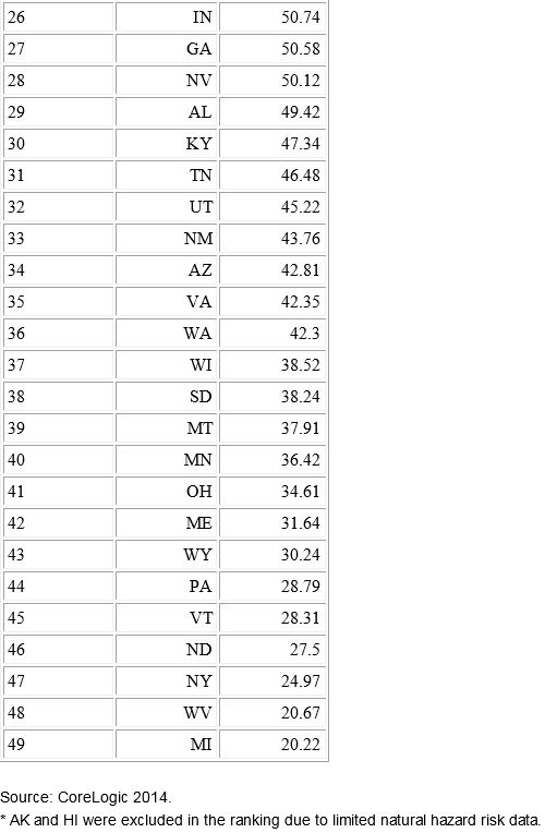
Potential for hurricanes and storm surges, the possibilities of wildfires and sinkholes, and an extensive coastline make Florida rank as the state with the highest risk of property damage from natural hazards, according to a new analysis by CoreLogic. Second on the list is Rhode Island, with Michigan coming in with the lowest ranking for risk.

The analysis was derived from the Hazard Risk Score (HRS), a new analytics tool that gathers data on multiple natural hazard risks and combines the data into a single score ranging from 0 to 100. The score indicates risk exposure at the individual property and location level, CoreLogic said. In calculating an overall score, the probability of an event and the frequency of past events are significant contributing factors to determine risk levels associated with individual hazards, along with each hazard’s risk contribution to total loss.

“Florida’s high level of risk is driven by the potential for hurricane winds and storm surge damage along its extensive Atlantic and Gulf coastline, as well as the added potential for sinkholes, flooding and wildfires. Michigan alternatively ranks low for most natural hazard risks, other than flooding,” Howard Botts, Ph.D., vice president and chief scientist for CoreLogic Spatial Solutions, said in a statement.

HRS measures risk concentration and pinpoints the riskiest places in the country. “This insight is critical in conducting comparative risk management nationwide and fully understanding exposure to potential natural hazard damage,” Botts said.

The tool can be used to improve decision-making and enhance business operations, including:

• Business continuity and disaster recovery planning

• Analyzing risks associated with properties

• Measuring savings of mitigation compared to the potential damage of a hazard

• Evaluating natural hazard levels of distribution and supplier networks

• Recognizing if underinsured or uninsured properties could be at risk of default

• Adverse selection avoidance and identification of good risk properties.


The Largest Natural Hazard Risks of 2012

2012 was a year of natural catastrophes. From Hurricane Sandy to the record-setting drought to the third most destructive wildfire season on record, the year was fraught with disasters that took a toll not only on communities nationwide, but on some of the world’s largest insurers. Today, CoreLogic issued its annual Natural Hazard Risk Summary, which details the most significant natural disasters that struck the United States in 2012. It notes the following:

Hurricanes

  • The single most destructive natural disaster in 2012 was Hurricane Sandy. In late October, the Category 1 storm generated record levels of storm surge along the northern New Jersey coast and in the New York City area, impacting more than five million residents across the region.
  • The first hurricane to make landfall in the U.
    buy stendra online cosmeticdermcenter.com/wp-content/uploads/2023/10/jpg/stendra.html no prescription pharmacy

    S. in 2012 was Category 1 Hurricane Isaac in late August, which caused an estimated $2 billion in insured losses around the New Orleans metro area.

Floods

  • Flood losses are expected to total approximately $10 billion in 2012, which would result in the third consecutive year of increasing flood damage in the U.S.
  • Earlier in the year, Tropical Storm Debby tracked slowly across the Florida peninsula in June, dropping at least 25 inches of rainfall along its path.
  • After months of sustained, widespread drought, Hurricane Isaac brought heavy rainfall and flooding to Louisiana in late August before continuing northward into the Midwest.
    buy arimidex online cosmeticdermcenter.com/wp-content/uploads/2023/10/jpg/arimidex.html no prescription pharmacy

Wildfires

  • The 2012 wildfire season was the third most destructive on record in the U.S. in terms of total acres burned as of early December.
  • The 15-year trend of fewer, but larger fires continued into 2012 with fewer than 51,000 individual wildfires across the country—the lowest number recorded since 1989.
  • Several of the individual fires that occurred in 2012 set records, including Colorado’s Waldo Canyon Fire, which damaged or destroyed 346 homes, and New Mexico’s Whitewater-Baldy Fire, which burned more than 297,000 acres.
  • NOAA continues to predict a pattern of drought conditions through the start of 2013, suggesting the potential for another increase in wildfire risk across much of the country. In the chart below, “SL” stands for short-term drought (typically less than six months) and “L” stands for long-term drought (typically more than six months).

Tornadoes

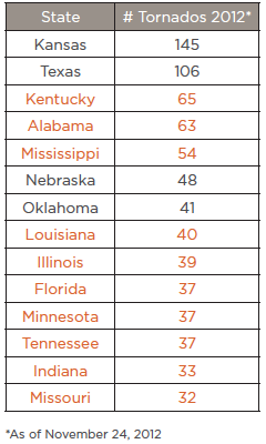
  • Tornado activity in 2012 was not strictly limited to the region commonly referred to as “Tornado Alley.” States located outside the central and southern Great Plains experienced a significant number of tornadoes this year. The chart below, from CoreLogic’s report, represents states with 30 or more tornadoes in 2012. States in orange are not typically considered part of “Tornado Alley.”
  • January 2012 was one of the most active Januaries since recording began in 1950, with a total of 79 tornadoes reported across the country.
  • In late February, tornadoes struck Illinois, Indiana, Kentucky and Ohio. Harrisburg, Ill., experienced the most concentrated destruction, with more than 225 homes and businesses damaged or destroyed and an estimated $475 million in total damage.

“Because the strength, severity and geographic impact of natural disaster events will change from year to year, an understanding of patterns in hazard activity, geographic vulnerabilities and the properties exposed to each different type of disaster is crucial to managing risk,” said Dr. Thomas Jeffery, senior hazard scientist for CoreLogic.

As we’ve seen with the natural catastrophes of 2012, it is important for insurers, homeowners and businesses to develop a more comprehensive evaluation of risk — one that includes typically non-traditional locations.

buy lasix online haveagreatsmile.com/wp-content/uploads/2023/10/jpg/lasix.html no prescription pharmacy