Immediate Vault Immediate Access

Amid Wildfires, California’s Emergency Warning Systems Take Heat

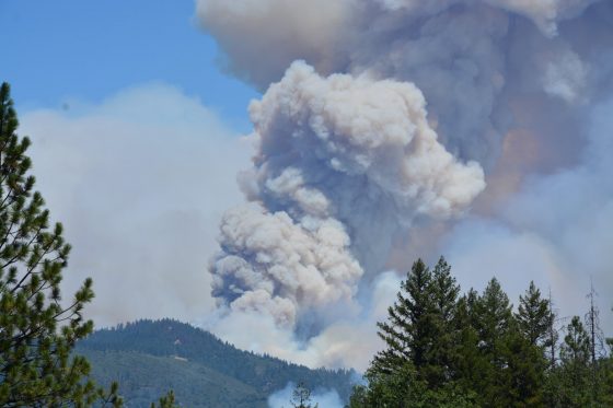
Overnight, the Mendocino Complex Fire in Northern California expanded far enough to oust the 2017 Thomas Fire as the largest wildfire in the state’s history. Comprising two joined fires, the Mendocino Complex Fire has burned through 443 square miles in the area north of San Francisco. As of Tuesday morning, the fires burned more than 140 structures, including at least 75 homes, and was 30% contained.

But California’s residents and businesses still should be on alert, as the incendiary activity doesn’t end there. An unprecedented 14,000 firefighters are combating between 12 and 16 wildfires in the state, according to the Department of Forestry and Fire Protection. Particular emphasis is in Northern California, where the fires in Mariposa and Shasta counties continue to threaten residents, businesses, and emergency responders. For 26 days, the Ferguson Fire in Mariposa County has burned nearly 90,000 acres and caused two fatalities. The fire is having a huge impact on areas near and around Yosemite National Park, which alerted the public that it had closed all but two entrances and roads.

Redding, a city 150 miles north of Sacramento, is the site of the Carr Fire, which has been ablaze for two weeks. Weather.com reported that the fire has caused seven deaths and the destruction of nearly 1,600 structures, the majority of which are homes.

The city of Redding launched an interactive map that provides residents with images of neighborhoods so they can check the status of their homes. Reports indicate that more than 1,800 structures are still in the path of the fire.

Despite such technological advances, many residents have questioned the effectiveness of the state’s emergency notification system, which they rely on for evacuation notices. The California Governor’s Office of Emergency Services currently uses an integrated California Public Alert and Warning System (CalPAWS) Plan to warn the public of danger.

Affected residents in several areas have claimed that they did not receive the CalPAWS evacuation order – including the great-grandmother who perished in the Carr fire in July with her two great-grandchildren. On Aug. 4, California Gov. Jerry Brown held a press conference in Shasta County to discuss the damage. But California’s emergency notification systems—and its unreliability in certain areas of the state—were a central focus of the conference.

Gov. Brown said he would consider legislation to improve alert systems, acknowledging local lawmakers’ proposals in an effort to create a statewide system that requires registration from all residents.

“I think we do need the best alert system we can get, and that’s what I would help the Legislature achieve,” Brown said, according to the Sacramento Bee. “There’s a lot of things we can do, and we can always do more … given the rising threats on the changing of the weather, the climate.”

The Bee reported that a bill with adoption plans for a uniform alert system has been drafted:

The bill, Senate Bill 833, would require counties to automatically sign up residents for a uniform cell phone alert system. It would also fund a standardized system equipped to push out alerts on all forms of media—radio, television, electronic highway billboards and landlines. County emergency managers would be required to undergo annual training on the latest alert technology.

Under such a plan, which would utilize the federal Wireless Emergency Alerts system, they’d have to opt out rather than sign up voluntarily.

Furthermore, the governor said he hopes to overhaul the state’s 911 system, which would de-centralize the calls and notifications to ensure more accurate messaging.

Also on Aug. 4, the White House approved California’s request for a Presidential Major Disaster Declaration to help with the impacts of the wildfire in Shasta County.

“This is part of a trenda new normalthat we’ve got to deal with. We’re dealing with it humanly, financially and governmentally,” Gov. Brown said during a media briefing at the Carr Fire Incident Command Post in Anderson, California. “These kinds of horrible situations bring people together, regardless of the lesser kind of ideologies and partisan considerations.”

Weather Threatens Oroville Dam Emergency Efforts

As measures are taken to repair a damaged spillway at the Oroville Dam in Northern California, weather forecasters are calling for rain later this week. Almost 200,000 people were evacuated from their homes below the dam, the largest in the country, on Feb. 12 as erosion of the dam’s emergency spillway threatened to flood the towns below.

While the situation was said to have stabilized on Sunday morning, conditions worsened and evacuation orders were issued. Roads in the area quickly backed up as a result, according to reports.

The dam’s main spillway was damaged after a winter season of record rains and snows following years of drought in the state.

Photo: California Department of Water Resources

California Representative John Garamendi told MSNBC that the evacuation was essential. “Fortunately when they were able to open the main spillway gates. That began to lower the reservoir level, because the water coming into the reservoir was about half of what they were able to expel down the main spillway, so it’s stabilized.”

The next issue, he said, is whether the spillway can be patched up “sufficiently to weather the storms that are clearly ahead of us.” Garamendi added that the months of March and April are the heavy storm season in the state.

Sheriff Kory Honea of Butte County said at a press conference that the Department of Water Resources (DWR) reported that the dam’s erosion is not advancing as rapidly as they thought. He said a plan is in place to plug the hole in the spillway by dropping large bags of rocks by helicopter. The DWR said that another measure being taken to relieve pressure on the spillway has been to raise the rate of discharge water from 55,000 cubic feet per second to 100,000 cfs, which it said has been working.

Helicopters transport large bags of rocks from the Oroville Dam parking lot, to the erosion site at the Oroville Dam auxiliary spillway in California, to help fight further erosion, February 13, 2017. Oroville is in Butte County. Florence Low / California Department of Water Resources

The New York Times reported that Northern California is close to 225% above normal rainfall levels since Oct. 1. According to the Times:

Repeated rounds of rain have pounded the area in recent weeks, rapidly raising the water level at Lake Oroville, the second-largest reservoir in California and a linchpin of the state’s water system. On Tuesday, a gaping hole opened in the main spillway that is used to release extra water. Early Saturday, an adjacent emergency spillway was also put into use, the first time water flowed over it since the dam was finished in 1968, department officials said.

State officials have said the 770-foot Oroville Dam itself, the nation’s tallest, is sound.

The problems with Oroville Dam are not a surprise to some. In 2005, during a relicensing process for the dam, three environmental groups warned the DWR of potential dangers with the emergency spillway, which is not a concrete spillway, but a concrete lip with a dirt hillside below. The concern was that the hillside could be easily eroded in the case of an emergency.

The Washington Post reported:

The upgrade would have cost millions of dollars and no one wanted to foot the bill, said Ronald Stork, senior policy advocate for Friends of the River, one of the groups that filed the motion.

“When the dam is overfull, water goes over that weir and down the hillside, taking much of the hillside with it,” Stork told The Washington Post. “That causes huge amounts of havoc. There’s roads, there’s transmission lines, power lines that are potentially in the way of that water going down that auxiliary spillway.”

Federal officials, however, determined that nothing was wrong and the emergency spillway, which can handle 350,000 cubic feet of water per second, “would perform as designed” and sediment resulting from erosion would be insignificant, according to a July 2006 memo from John Onderdonk, then a senior civil engineer for the Federal Energy Regulatory Commission.

Garamendi said that “What happened with the widening of the sinkhole was the result of someone overlooking the problems, including the fact that there was no concrete apron on the spillway.”

He also noted that while there will most likely be federal dollars to help rebuild the dam, “This is just one really startling, quite tragic and potentially catastrophic example of what’s happened to the infrastructure across America. We’ve seen bridges collapse in Minnesota, we’ve seen them on I-5 in Washington State and now this reservoir, which is the linchpin of California’s water system.”