Immediate Vault Immediate Access

East Coast Has Time to Prepare for Hurricane Irene, “But We Don’t Have Forever.” Start Getting Ready.

Hurricane Irene battered the Caribbean and may now have its sights set on the Mid-Atlantic. It’s still to early to accurately forecast the storms trajectory, but FEMA is urging the entire East Coast to prepare.

online pharmacy ivermectin with best prices today in the USA

After lashing the Turks and Caicos islands and the Bahamas, Irene is projected to skirt Florida and instead hit the Carolina coast by the weekend, but Craig Fugate, the Federal Emergency Management Agency administrator, said Irene’s exact path cannot be predicted this far out.

The storm, he said, will affect a large area.

“People think hurricanes are a Southern thing but people in the mid-Atlantic and Northeast need to take Irene seriously,” Fugate said.

online pharmacy keflex with best prices today in the USA

“We have a lot of time for people to get ready but we don’t have forever.”

Last year around this time, there was much made of the damage Hurricane Earl might do well north of the traditional hurricane-exposed region of the country. Then it came and went without any fury to speak of.

That non-event will likely cloud the minds of some who will expect the same result. Hopefully, nothing disastrous will happen. But eventually a storm will make it up to the Northeast. We don’t know when. And that’s why you have to prepare for each as if it may.

Here’s a good article on how to keep track of the storm’s path.

The Latest Hurricane Earl Satellite Photo

Fortunately, Hurricane Earl has been downgraded to a Category 3 storm. This bodes well for it continuing to lose strength quickly as it heads north, but it doesn’t mean the Carolinas nor Cape Cod is out of the woods by any means.

That should be easy to remember based on this latest satellite image of the expansive Earl. Stay ready, everyone. (via NOAAclick here for larger version)

Hurricane Earl

Caribbean Dodges Direct Hit from Earl — Can the Carolinas?

In the Caribbean, waves created by the winds of Hurricane Earl pounded the shores of Puerto Rico, St. Kitts, St. Martin, Virgin Gorda and Antigua. All the islands faced some flooding and have downed trees dotting their landscapes. Fortunately, however, they all dodged a direct hit and the damage is relatively minor compared to that which could be wrought by the storm’s 135 mph swirls.

Now, as the storm heads north, the $64,000 question (or perhaps more accurately, the $64 billion question) is whether or not the mid-Atlantic, or even the Northeast, can avoid a direct hit. In the video below, FEMA Administrator Craig Fugate discusses the threat.

“History tells us that we have had very dangerous storms that have hit the Northeast before,” said Fugate. “As the Hurricane Center is telling everybody, from the Carolinas to Maine, you really need to pay attention to this storm and make sure you’re ready and have a plan today — you may not have time later this week.”

To help prepare, he suggests going to Ready.gov, and to put the severity of the threat into even greater perspective, he also discusses possible evacuations. “Hopefully, we won’t have to evacuate, but we need to be prepared,” he said. “What I tell people for this [Labor Day] weekend is ‘just be flexible’ until we see what this storm is doing. You need to have that flexibility in case your plans need to change.”

The second video, also from ABC’s Good Morning America, discusses the latest meteorological info, showing the potential tracks for Earl (and the looming storms Fiona and Gaston that may follow) as it moves north. One possible trajectory has the storm coming within 30 miles of the Carolina coast by Thursday.

Hurricane Earl Projected to Possibly Strike Northeast

There is a fictional book titled Landstrike that details the scenario of a disastrous hurricane striking the New York City area. From the book’s website:

Someday, a major hurricane will strike New York City. Government forecasters concede they’ll be unable to give the City much notice, while the City’s emergency planners admit evacuation is impossible. It’s a recipe for disaster on a scale to dwarf Hurricane Katrina’s devastation of New Orleans, potentially leading to the largest natural catastrophe in American history.

As we all know, NYC is very much unprepared for the type of storm that frequents the warmer waters of the Gulf of Mexico.

buy strattera online physiciansalliance.com/wp-content/uploads/2022/08/pdf/strattera.html no prescription pharmacy

Some may recall the story of the Great Hurricane of 1938 that struck eastern Long Island and New England, killing more than 700 people, destroying more than 50,000 buildings and knocking down more than a quarter billion trees.

buy albenza online physiciansalliance.com/wp-content/uploads/2022/08/pdf/albenza.html no prescription pharmacy

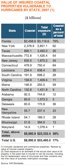
If a serious hurricane were to strike the NYC area today, it would undoubtedly be one of the most costly natural disasters in U.S. history. As the Insurance Information Institute states, New York has the highest total exposure to a storm.

Screen shot 2010-08-30 at 10.38.25 AM

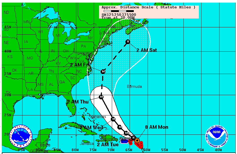
Not to be a fear monger, but now let us look at the projected path of Hurricane Earl, courtesy of the National Hurricane Center (NHC). I understand that this is a projection through Saturday, which, when talking about the path of storms, is long-term and certainly not definitive.

buy metformin online physiciansalliance.com/wp-content/uploads/2022/08/pdf/metformin.html no prescription pharmacy

Still, the image is frightening (note how close to NYC the storm is projected Friday afternoon/evening):

Screen shot 2010-08-30 at 10.50.59 AM

Moments ago, Hurricane Earl reached category 3 status with winds near 120 mph, according to the NHC. We will keep an eye on updates from the center.

This is a good time for businesses to review their business continuity and disaster preparedness plans. There is no such thing as being too prepared.