Immediate Vault Immediate Access

Three Tips for Using Telematics to Keep Drivers Safe This Winter

Speeding. Harsh stops. Rapid acceleration. Cornering. Fleet managers are likely familiar with these buzzwords related to driver behavior, but what is the real impact of not fixing the way employees operate company vehicles?

According to the National Highway Traffic Safety Administration, driver error causes 94% of all vehicle collisions. Along with the physical and psychological consequences that accidents cause all parties, they can also have far-reaching financial liabilities for businesses if company drivers are found to be the negligent party.

Driving in winter weather amplifies these risks, and without the proper precautions, a company’s drivers may cause a fatal accident on icy or snow-covered roads if they speed when running late, make harsh stops when distracted, or rapidly accelerate in traffic.

We know the basic rules of thumb for driving in winter weather: Slow down, leave extra distance between your vehicle and the one in front of you, turn the wheel into a skid. But for employees who drive company vehicles, there is an added layer to safer driving in winter weather: telematics. Telematics are devices that gather and send data from the vehicle to fleet operators, providing insight into drivers’ actions and their safety, and other information like the conditions of the vehicles and roads.

Here are three tips for using telematics to keep drivers safe during winter weather:

  1. Closely monitor driver speed

Usually, companies set real-time speeding alerts with some room for driver error. Leaving this room for drivers includes setting posted speed alerts that do not trigger unless the driver is traveling at least 10 miles per hour over the posted speed limit, or setting high speeding thresholds in general where the alert only hits if the driver is going above 80 miles per hour.

A best practice during winter months is to set these thresholds much lower and become more stringent on violations. For example, setting the posted speed limit violation threshold to 2 miles per hour over the posted speed of the road can ensure that drivers are staying close to the limit and taking their time getting to their next stop.

buy isotroin online www.handrehab.us/images/patterns/jpg/isotroin.html no prescription pharmacy

  1. Stay alert on maintenance demands

Telematics solutions can monitor for various vehicle maintenance needs, such as oil life and tire pressure, in real time and notify the fleet manager when maintenance is needed.

Batteries die faster in cold weather, especially when they sit for extended periods. By using a telematics solution, fleet managers can receive alerts when batteries drop below a specific voltage. Setting this alert serves as a reminder to start the vehicle or investigate to prevent a dead battery.

This knowledge can save a fleet thousands of dollars in unnecessary maintenance costs and improve safety for drivers by reducing the number of faulty vehicles.

  1. Proactively coach drivers to navigate tough road conditions

Speeding, rapid acceleration and harsh braking should always be avoided, but these actions are particularly dangerous in winter weather environments. By harnessing GPS telematics and predictive analytics, fleet managers can catch patterns of unsafe driving behavior before it results in a serious accident. Rather than rely on general training for all drivers, fleet managers can provide one-on-one evaluations that focus on each driver’s pain points using real-time alerts, reactive reports and driver scorecards.

Enforcing a business safety culture backed by actionable telematics data can ultimately help companies ensure the safety of their employees and the public in real time. No business wants its drivers to be put in harm’s way on the road, but safety also makes good business sense.

buy prelone online www.handrehab.us/images/patterns/jpg/prelone.html no prescription pharmacy

Company vehicles are driving billboards, and along with the potential to put the public in harm’s way, it will ultimately hurt the bottom line if the brand is associated with accidents, fatalities and poor driving habits.

buy spiriva online www.handrehab.us/images/patterns/jpg/spiriva.html no prescription pharmacy

California Unveils New Earthquake Warning System

California governor Gavin Newsom announced a new state-wide system, created in cooperation with the U.S. Geological Survey, that will provide California residents with an early warning for coming earthquakes. Part of the system is an emergency messaging system that sends text warnings, similar to those that cell phone users already get for floods and missing persons. The other component of the system is a new app called MyShake, which will give people “tens of seconds” advance notice before a quake strikes. If you are in a house, that might be enough time to get to a safe spot away from falling furniture.

buy xtandi online rxbio.com/images/milestones/jpg/xtandi.html no prescription pharmacy

If you are on the road, it may be enough time to pull off the road or stop before a bridge or tunnel.

buy fildena online rxbio.com/images/milestones/jpg/fildena.html no prescription pharmacy

According to the California Governor’s Office of Emergency Services, “The system uses ground motion sensors from across the state to detect earthquakes before humans can feel them and will notify Californians so that they can ‘Drop, cover and hold on’ in advance of an earthquake.” A similar app called ShakeAlertLA was unveiled in January, but was only available to L.A. residents. Additionally, an early warning system had already been in place in California, but many believed that it was not sensitive enough. This summer, after two major earthquakes hit a desert area outside of Los Angeles the week of July 4th, L.A. residents complained that they had not received any warning because the quake’s distance from the city meant that it was strong enough to set off the sensors in Los Angeles.

Newsom announced the new system on the 30th anniversary of the Loma Prieta earthquake that hit San Francisco in 1989, killing 63 people and causing a reported $6 billion in 1989 dollars (more than $12 billion today) in property damage. A spokesperson for the Governor’s Office of Emergency Services said that if the new system had been in place at the time of Loma Prieta, residents would have gotten a warning 15 to 18 seconds before the earthquake hit.

Shortly after its release, two earthquakes in San Francisco tested the app and it was able to warn users within a median time of 2.1 seconds for the first quake and 1.

buy zestril online rxbio.com/images/milestones/jpg/zestril.html no prescription pharmacy

6 seconds for the second. Officials said that the app will improve as it is tested further, and will also be available in Spanish and other languages in the near future, allowing it to reach more California residents.

California has a 99.7% chance of a 6.7 magnitude earthquake or larger in the next 30 years, according to Dr. William Leith of the U.S. Department of the Interior’s U.S. Geological Survey. And while the new system could protect residents from bodily harm, the same cannot be said for their property.

According to a 2018 California Department of Insurance report, only 13% of state residents with homeowner’s insurance purchased earthquake coverage in 2017. The total for all Californians is likely lower, around 10%, leaving many vulnerable to high costs for repairing and rebuilding property.

National Flood Insurance Program Set to Expire

As a tropical storm battered parts of Texas with more than 40 inches of rain in 72 hours last week, Congress is debating whether to extend the National Flood Insurance Program, which expires on September 30. The NFIP is a government-run flood insurance plan that covers 5 million policies and is an alternative to the relatively shallow private flood insurance market. Since the passage of the National Flood Insurance Act of 1968, Congress has often waited until the last minute to reauthorized the program before its expiration and passed only short-term extensions (12 since 2017).

Last week, the U.S. House of Representatives passed a continuing resolution to keep the federal government funded through November 21 and prevent a government shutdown. This measure included an extension for the NFIP through the same date. But it is unclear whether the Senate will pass the resolution or allow a shutdown.

The House of Representatives Financial Services Committee unanimously passed a bill titled the National Flood Insurance Program Reauthorization Act of 2019 (H.R. 3167), which would reauthorize the NFIP for five years and provide funding for flood mapping and flood mitigation programs. It would also mandate a number of reforms, including allowing policyholders to get refunds if they cancel their policy before its expiration date, eliminating penalties if insureds leave the NFIP for the private market, and requiring the NFIP to increase premium rates each year.

On the Senate side, there is a bill of the same name that would also extend the NFIP for five years. The bills would also cap annual rate increases at 9% (as opposed to the current law, which allows increases by up to 25% annually), making the program more affordable, especially for low-income policyholders. Additionally, it includes provisions to protect homebuyers and renters by mandating flood risk and prior flood damage disclosures, and also funds flood mapping modernization and mitigation. As of this writing, the Senate has not voted on the measure.

Climate change has exacerbated annual flooding across the United States, making storms more violent, frequent and costly. In its June report on the flood outlook for 2019, the National Oceanic and Atmospheric Administration noted that non-storm, high-tide flooding “is increasingly common due to years of relative sea level increases. It no longer takes a storm or a hurricane to cause flooding in many coastal areas.” And in May, NASA said that the United States had experienced record-setting precipitation, characterizing it as the “soggiest 12 months in 124 years of modern record-keeping.”

They also mean millions more in property damage, which in turn means more people getting payouts from the NFIP. In fact, the series of hurricanes that hit the United States in 2017 and 2018 also hit the NFIP hard—the program lost billions of dollars in payouts, leading the government to pass a disaster relief bill that helped the NFIP pay the claims. The Federal Emergency Management Agency (FEMA), which runs the NFIP, aims to double the number of people who have flood insurance by 2023, but according to E&E News analysis, coverage in the United States has declined by 31% since 2011, leaving many without protection if they are hit with flooding.

In 2012, Congress passed a law allowing federal agencies to begin accepting private flood policies, but the market has been sluggish to fill the gaps. Some are stepping in—indeed, the American Association of Insurance Services (AAIS) today announced a partnership with Munich Reinsurance America, Inc. (Munch Re) to provide flood insurance aimed at homeowners outside major flood zones. But with few other private insurance companies offering flood policies, if the NFIP is not reauthorized, this could leave more than half-a-million people across the country without coverage.

Catastrophic Floods More Frequent in 2019

Last week, after already experiencing heavy rainfalls and flooding, New Orleans was preparing for tropical storm Barry, expecting the storm to overflow or even breach the city’s levees. Flights in and out of the city were cancelled, as were concerts and other public events, as the city braced for catastrophe. Barry ended up narrowly missing New Orleans, and instead moved inland, drenching other parts of Louisiana and Mississippi and causing floods and mass power outages in those areas. It was yet another example of how major flooding has become a normal occurrence for many regions of the country, and by all indications, it is becoming worse each year.

The National Oceanic and Atmospheric Administration (NOAA) stated in its report 2017 State of U.S. High Tide Flooding and 2018 Outlook that “The projected increase in high tide flooding in 2018 may be as much as 60 percent higher across U.S. coastlines as compared to typical flooding about 20 years ago and 100% higher than 30 years ago.” This prediction turned out to be accurate, as the United States saw massive flooding throughout 2018, including “sunny-day” or “high-tide” flooding that occurs during high tides outside of hurricane events.

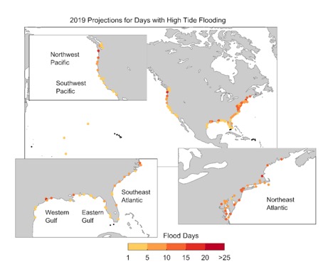
In its recent report on 2018 high-tide flooding and 2019 outlook, the NOAA said that these floods’ median frequency in 2018 “reached 5 days, which tied the historical record of 2015.” Of the 98 observed locations along the U.S. coastline, 12 reportedly broke or tied their all-time records for high-tide flooding in 2018. And now, the NOAA is predicting that 2019 could be even worse.

The NOAA noted that high-tide flooding “is increasingly common due to years of relative sea level increases. It no longer takes a strong storm or a hurricane to cause flooding in many coastal areas.” The Union of Concerned Scientists has said that sea level rise is accelerating, that “sea levels in the U.S. are rising fastest along the East Coast and Gulf of Mexico,” and that the primary reason for this sea level rise is climate change melting land ice and heating oceans.

According to the NOAA’s 2019 projections, it expects high-tide flooding along the U.S. coastlines this year to reach double the numbers from 2000. Additionally, “the Northeast Atlantic could see a 140% increase, the Southeast could see a 190% increase, and the Western Gulf of Mexico could see a 130% increase.”

Almost 40% of the U.S. population lives in coastal areas, and could be at risk from flooding effects. With the start of hurricane season, these dangers will only increase as storms batter the coasts. Even before Barry threatened, New Orleans faced massive flooding last week, while Pittsburgh contended with flash floods. And the week before, heavy rains left Washington, D.C. and surrounding towns swimming in water that overwhelmed the city’s storm water pipes.

These increasing floods mean serious losses for people, municipalities and businesses. The recent DC-area floods reportedly caused $3.5 million in damage to Arlington, Virginia county infrastructure alone. In March, a “bomb cyclone” hit Nebraska, with heavy rainfall causing damages totaling more than $1.3 billion. This figure includes $449 million in road, levee and other infrastructure damage, as well as serious damage to more than 2,000 homes and 340 businesses. Iowa also experienced flooding that caused water treatment plants to shut down, depriving two cities’ residents of fresh water. And across the Midwest, agriculture was also hit hard by flooding, slowing corn and soybean planting. The delay may decrease harvests by at least 8% and increase prices worldwide.

As Risk Management Monitor has previously reported, Texas A&M University at Galveston and the Texas General Land Office examined the 50-year impact of a major storm hitting Galveston Bay on the Texas coast near Houston, finding that major storm events that caused flooding would have huge secondary effects on the economy, both locally and nationally.

Various states, including those along the Mississippi River, have already enacted flood control measures like levees, dams and flood walls, but have seen this year’s increased flooding defeat these measures. Others have encouraged residents to purchase flood insurance to offset losses. But the increasing scope of future floods may mean that these steps are not enough. Though tropical storm Barry missed New Orleans, experts have still expressed concern about coming storms possibly “topping” the city’s levees, which could cause even more damage to the already-flooded city.