Immediate Vault Immediate Access

October 2015 the Warmest Ever Recorded

It isn’t just your imagination: October 2015 was the warmest on record worldwide, and saw the greatest above-average deviation for any month. According to the National Oceanic and Atmospheric Administration, the average temperature across global land and ocean surfaces was 1.

buy zantac online healthymomsandbabes.org/wp-content/uploads/2023/10/jpg/zantac.html no prescription pharmacy

76 °F above the 20th century average, surpassing the previous record set last year by 0.36 °F. The globally-averaged land surface temperature was 2.39°F above the 20th century average—the highest for October in 136 years of NOAA records.

buy mobic online healthymomsandbabes.org/wp-content/uploads/2023/10/jpg/mobic.html no prescription pharmacy

NOAA land and ocean temp percentiles

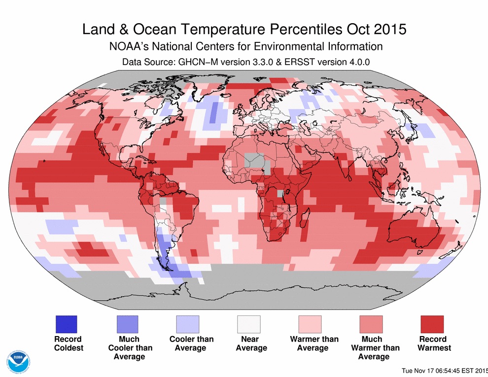
October was also the warmest month ever compared to average, out of a total of 1,630 months. What’s more, NOAA reports, eight of the first 10 months of the year have been record warm for their respective months—also a record number of broken records. Globally-averaged land surface and sea surface temperatures have been 1.55 °F and 2.30 °F above average, respectively, surpassing all previous records. With many months setting record high temperatures by unprecedented margins, NOAA said in August that there was a 97% chance that 2015 would secure the title of the warmest year on record, and it remains solidly on track.

In early November, the Met Office, Britain’s national weather service, and NASA both reported that the Earth’s average temperature is likely to rise 1 °C above pre-industrial levels for the first time by the end of 2015. This milestone is significant since it marks the halfway point to two degrees Celsius, the internationally accepted limit for avoiding the worst consequences of climate change, the Washington Post reported. Since 2000, global monthly heat records have been broken 32 times, yet the last time a monthly cold record was set was in 1916, according to CBS News.

Some of the heat is likely due to a strong El Nino event in the Eastern Pacific that continues to gather strength.

buy zocor online healthymomsandbabes.org/wp-content/uploads/2023/10/jpg/zocor.html no prescription pharmacy

This year’s El Nino is already one of the three strongest ever seen, CNN reports, but cannot account for all of the year’s warmth, as 13 of the 15 warmest years on record have occurred since 2000. Rather, it is the combination of long-term warming and the strong El Nino pushing Earth toward its second consecutive warmest year on record.

According to Aon Benfield’s October 2015 Catastrophe Report, there were three billion-dollar weather-related disasters in October: flooding in South Carolina with economic losses of at least $2 billion, $4.2 billion in damage from Typhoon Mujigae in China, and $1 billion in damage from flash flooding in France. The firm estimates worldwide economic losses from October to total more than $10 billion. There have been 21 billion-dollar weather events through October 2015, Aon reported, on pace for a lower total than the annual average of 28.

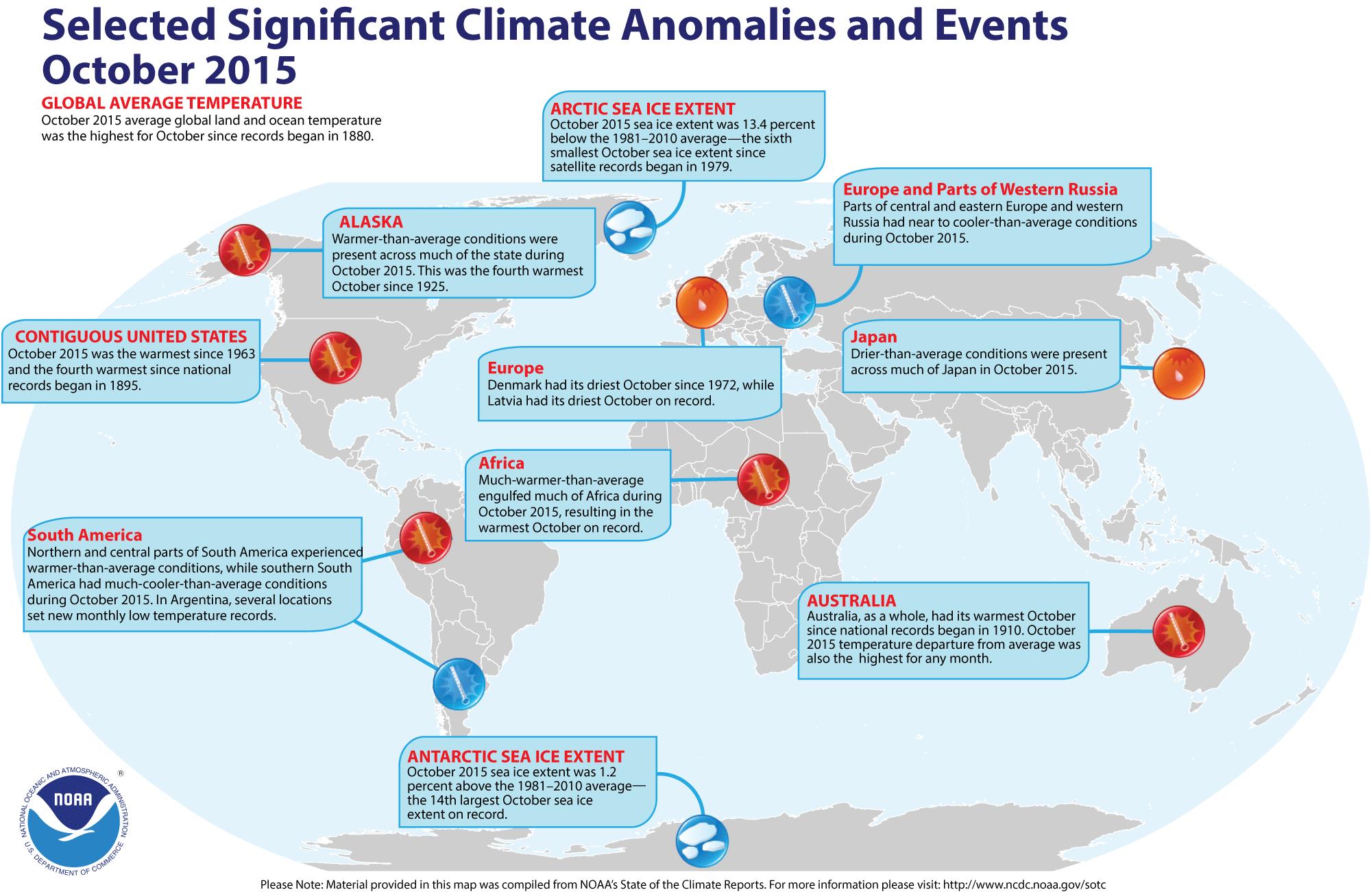
Check out the infographic below for more of the major climate anomalies and events from October 2015:

NOAA october climate anomalies

Prepare Now for Spring Thaw Flooding

After a harsh, cold winter, the clear, sunny skies and rising temperatures of spring are much appreciated. Businesses, however, also need to be ready for the possibility of flooding that may result from heavy rains combined with melting ice and snow.

The National Oceanic and Atmospheric Administration (NOAA) notes that flooding causes more damage in the United States than any other weather-related event. On average, flooding causes $8 billion in damages and 89 fatalities annually. Warming weather also often brings ice jams along rivers, streams and creeks, which can cause further flooding.

“In addition to the threat of floods that occur when severe weather hits, snow and ice have been piling up in many areas of the U.S. this winter,” Bill Boyd, senior vice president with CNA Risk Control, said in a statement. “When temperatures rapidly increase, so does the rate at which snow and ice melt…” which can create serious problems for those heavily affected this winter. “As spring temperatures begin to rise, it’s imperative for businesses to create emergency plans for flooding, which could cause costly property damage or disrupt operations,” he said.

According to NOAA:

Snowmelt and the breakup of river ice often occur at about the same time. Ice jams often form as a result of the sudden push exerted on the ice by a surge of runoff into the river associated with snowmelt. Ice jams can act as dams on the river that result in flooding behind the dam until the ice melts or the jam weakens to the point that the ice releases and moves downstream. A serious ice jam will threaten areas upstream and downstream of its location. Six inch thick ice can destroy large trees and knock houses off their foundations. Once an ice jam gives way, a location may experience a flash flood as all the water and debris that was trapped, rushes downstream.

CNA offers these tips for businesses to minimize loss during the thawing season:

Create a flood preparation plan.

Keep water out with barriers, sandbags and other devices.

Relocate materials from lower levels. In some cases, this may simply mean placing stored items on      one or two pallets, or moving items from lower shelves or racks to upper levels.

Review shutdown procedures for affected processes, especially hazardous processes.

Check to make sure drainage, including roof drains, are open and flowing freely.

Thaw Edition tools, checklists and bulletins, can be found at www.cna.com/actnow.

NOAA Releases 2014 Hurricane Season Outlook

hurricane season

In a press conference this morning, the Climate Prediction Center of the National Oceanic and Atmospheric Administration (NOAA) released its official 2014 outlook for the Atlantic and Eastern Pacific hurricane seasons.

The East Coast may see below-average activity this year, thanks, in part, to the anticipated development of El Nino this summer. According to NOAA, “El Niño causes stronger wind shear, which reduces the number and intensity of tropical storms and hurricanes. El Niño can also strengthen the trade winds and increase the atmospheric stability across the tropical Atlantic, making it more difficult for cloud systems coming off of Africa to intensify into tropical storms.”

There is a 50% chance for a below-average season, a 40% chance of a near-normal season, and only a 10% chance of an above-average season, the center predicts. “For the six-month hurricane season, which begins June 1, NOAA predicts a 70 percent likelihood of 8 to 13 named storms (winds of 39 mph or higher), of which three to six could become hurricanes (winds of 74 mph or higher), including one to two major hurricanes (Category 3, 4 or 5; winds of 111 mph or higher),” they announced.

2014 Atlantic Hurricane OutlookBut the forecast is no reason to take preparations lightly. “Thanks to the environmental intelligence from NOAA’s network of earth observations, our scientists and meteorologists can provide life-saving products like our new storm surge threat map and our hurricane forecasts,” said Kathryn Sullivan, Ph.D., NOAA administrator. “And even though we expect El Niño to suppress the number of storms this season, it’s important to remember it takes only one land-falling storm to cause a disaster.”

On the West Coast, it may be a more tumultuous summer. The outlook calls for a 50% chance of an above-normal season, a 40% chance of a near-normal season, and a 10% chance of a below-normal season. The center predicts there is a 70% chance of 14 to 20 named storms, which includes 7 to 11 hurricanes, of which 3 to 6 are expected to become major hurricanes (Category 3, 4 or 5 on the Saffir-Simpson Hurricane Wind Scale).

online pharmacy flagyl with best prices today in the USA

“The key climate factor behind the outlook is the likely development of El Niño this summer. El Niño decreases the vertical wind shear over the eastern tropical Pacific, favoring more and stronger tropical storms and hurricanes,” said Gerry Bell, Ph.

online pharmacy reglan with best prices today in the USA

D., lead seasonal hurricane forecaster with NOAA’s Climate Prediction Center. “The eastern Pacific has been in an era of low activity for hurricanes since 1995, but this pattern will be offset in 2014 by the impacts of El Niño.

online pharmacy paxil with best prices today in the USA

Next week (May 25-31) is National Hurricane Preparedness Week, and NOAA and FEMA will be offering additional tips and insight on their websites ahead of the official start of hurricane season on June 1.

2013 Hurricane Season: Active Storms Ahead

Saturday, June 1, marks the beginning of the 2013 Atlantic hurricane season. Forecasters from Colorado State University predict 18 named storms for the 2013 season, with nine of those forecasted to become hurricanes and four expected to be major hurricanes. The National Oceanic and Atmospheric Administration’s Climate Prediction Center warns there could be even more storms to hit the Sunshine State — up to 20, in fact, compared to the average of 12. If these and other predictions are right, Florida will see its share of storms this season.

But Floridians are not oblivious to these stats. As the the June issue of Risk Management states:

Regardless of the predictions, many Floridians were already expecting to be hit. The state that is geographically most vulnerable to Atlantic storms and has the longest coastline among the lower 48 (1,350 miles) has been spared each of the past seven years. Hurricane Wilma, one of seven major hurricanes that made landfall in the United States during the historic 2005 season (the year of Katrina), was the last storm to punish Florida.

With 2013’s predictions being far worse than those of 2012, businesses should begin preparing now. According to the Insurance Information Institute, 15 to 40% of businesses fail following a natural disaster.

Of those businesses that recover, on average, it takes about 11.5 days for them to become fully operational. This is a recipe for serious revenue and customer loss.

Bob Boyd, president and CEO of Agility Recovery, a provider of business continuity and disaster recovery solutions, provides the following advice for businesses in the path of hurricanes (or any natural disaster, for that matter).

Before the Storm

  • Ensure you have tested and activated your crisis communications plan prior to the storm’s approach. Even if the storm isn’t on a direct path to your location, activating this part of your plan will ensure reliable communications with your stakeholders.
  • Backup all data on servers and personal computers, and ensure you are able to remotely access and restore the data to an alternate site without delay.
  • Move vital records, equipment, supplies and inventory to a safe or fortified location.

    Postpone any future deliveries or shipments until the storm passes and transportation routes are passable.

  • Fill fuel tanks of generators and all company‐owned vehicles, and ensure employees are familiar with your emergency transportation plan for critical staff. Plan ahead for interruptions including curfews, law enforcement roadblocks, mass transit shut-downs, and impassable roads and bridges.
  • Enable remote access to your company’s website and social media channels to ensure constant communication with stakeholders. Contact the media ahead of time to make sure they know how to reach your leadership and spokespersons.

During the Storm

  • Ensure employees are away from wind and flood hazards and know the company policy regarding inclement weather. Take into account the fact that coastal flooding and storm surge are the most destructive and deadly forces during a hurricane.
  • Establish teams working on a 24-hour schedule to monitor any equipment that must consistently remain on line.
  • Preemptively shut off any unnecessary electrical switches to prevent surges or electrical shorts and accidents before the necessary checks are completed post-landfall.

After the Storm

  • Watch and listen to local news and online media channels for damage reports, transportation outages, lingering flooded areas and other potential dangers prior to assessing your facilities.
  • Establish and follow company policies for limiting access to your facilities until the area has been declared officially safe by local law enforcement, inspectors or company officials.
  • Begin contacting employees, suppliers, critical partners and other stakeholders to ensure their safety and ability to return to work.
  • Begin salvage as soon as possible to prevent further damage to facilities, inventory and assets. Begin work to restore any critical business functions that have been interrupted by the storm.

As we saw with the last two major hurricanes (Katrina and Sandy), preparation is paramount. In the New York area, Governor Cuomo marked this past week as Hurricane Preparedness Week — asking the state’s residents to review their preparations for the upcoming season. With 2013 predictions well above the seasonal average, this is advice every Atlantic coastal state should take seriously.