Immediate Vault Immediate Access

Flood, Wind Dominant Natural Hazards in 2016

While most natural hazards occurring in the United States last year saw average or below average activity, the exceptions were flood and wind, according to the CoreLogic report Natural Hazard Risk Summary and Analysis, released today.

Severe flood events driven by substantial rainfall were the dominant natural hazards, with Louisiana and North Carolina floods being the major loss contributors. As in 2015, hurricanes and tropical storms in 2016 continued to cause inland flooding through increased and intense rainfall—even when not making landfall, according to the report.

The National Oceanic and Atmospheric Administration (NOAA) said there were 12 individual weather and climate disaster events in the U.S. with losses exceeding $1 billion in 2016.

According to the report:

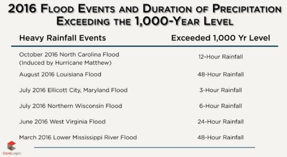
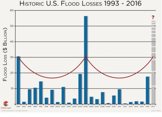
  • Based on NOAA and CoreLogic analysis, the overall flood loss in 2016, driven by six, 1,000-year plus rain events, was approximately $17 billion, which is six times greater than the overall flood damage experienced in 2015.
  • The U.S. Geological Survey (USGS) recorded 943 earthquakes of magnitude 3.0 or greater in 2016, with more than 60 percent of these earthquakes located in Oklahoma.
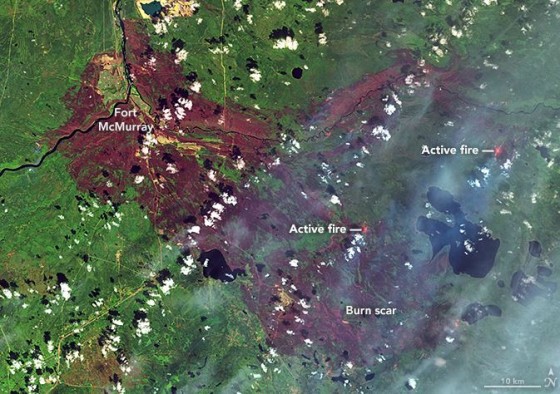
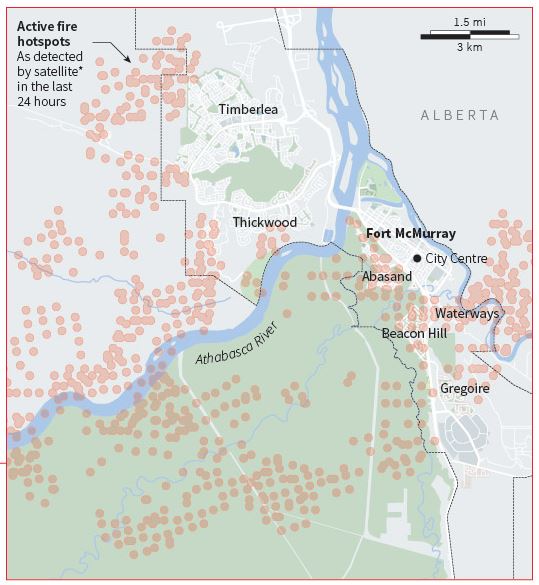
  • The National Interagency Fire Center (NIFC) reported a total of 5,415,121 acres burned from 62,864 separate fires in 2016.
    buy arimidex online achievephysiorehab.ca/wp-content/uploads/2023/10/jpg/arimidex.html no prescription pharmacy

    While the total acres burned in 2016 fell below the 10-year average, significant losses occurred, with thousands of homes in California and Tennessee destroyed by several smaller fires that burned in populated areas.

  • Wind activity in 2016 was slightly above average, due in large part to strong winds brought by Hurricane Matthew.
    buy mobic online achievephysiorehab.ca/wp-content/uploads/2023/10/jpg/mobic.html no prescription pharmacy

  • Hail activity in 2016 was near the average, and Texas experienced the worst of this natural hazard.
  • Tornado activity in 2016 was near average compared with previous years.
  • Hurricane Matthew developed late in the year and grew to a Category 5 storm, resulting in substantial damage along the southeastern seaboard.
  • There were below-average levels of tropical cyclone activity in the western North Pacific Basin encompassing East and Southeast Asia in 2016.

However, 2016 became known as the year without a winter. Nine winter storms impacted the U.S. in 2016, the most notable being the late-January winter storm in New York.

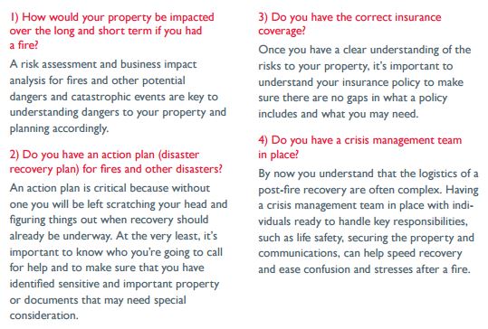
“History has continually shown us that it is impossible to determine exactly when or where the next wildfire, flood or earthquake will strike, which is why preparedness, response and post-loss assessment are paramount,” CoreLogic said.

Wildfires a Reminder to Update Disaster Preparedness Plans

Raging across the country, threatening businesses and residences alike, wildfires are a reality, burning a reported 1.

buy proscar online www.dino-dds.com/wp-content/uploads/2023/10/proscar.html no prescription pharmacy

9 million acres in the U.S. so far this year. West of Santa Barbara, firefighters have battled an intense fire for almost a week. Wildfires are also burning in Arizona and New Mexico. In Canada, the Fort McMurray blaze burned for weeks and scorched some 2,400 square miles of land—more than 1.4 million acres. In five of the past 10 years, in fact, wildfires have ranked among the top 20 worldwide loss events.

Interstate2

Companies that haven’t already done so may want to assess the impact such a disaster could have on their business as well as what actions can be taken to mitigate damage.

buy vilitra online www.dino-dds.com/wp-content/uploads/2023/10/vilitra.html no prescription pharmacy

While most businesses believe they are prepared for a fire, especially if their building is equipped with fire alarms, fire extinguishers, smoke detectors and an evacuation plan, these measures may not be enough when stress and confusion take over, according to Interstate.

Organizations could face utility interruption, impacting gas and phone syDocument recovery3stems; they may have flooding from sprinklers, which, mixed with soot, can cause other complications; there may be smoke damage, which can by carried throughout a building through air conditioning systems; and there can be chemical residue from fire suppression systems.

There also may be asbestos hazards from older building materials, ceiling and floor tiles and pipe insulation.

Planning ahead for data loss resulting from damaged computers and burned paper documents is also advised.

buy tenormin online www.dino-dds.com/wp-content/uploads/2023/10/tenormin.html no prescription pharmacy

Interstate lists four questions companies need to ask in advance of such a disaster:
Interstate 1

Fort McMurray Wildfire Insured Losses Up to $6.9 Billion

Ft-McMurray map

NASA Fort McMurray wildfire map

Insured loss estimates from the wildfire in Fort McMurray, Alberta, Canada, are projected between $3.4 billion and $6.9 billion, catastrophe modeling firm AIR Worldwide reported. Officials are still in the early stages of assessing damage caused by the wildfire that began on May 1 and quickly spread from forests to neighborhoods, outpacing local firefighters’ capacity to contain it. According to AIR, the Fort McMurray wildfire is the costliest natural disaster in Canada’s history.

The fire had initially moved away from Fort McMurray, but shifted back toward the city this week, causing evacuations for the second time. About 500 to 600 people were evacuated from four small work camps, Alberta Premier Rachel Notley said in a news conference on Monday.

The fire is still uncontained and, as of May 14, had covered nearly 600,000 acres, mainly in wildlands and away from population centers. Winds are now calmer and temperatures have lowered, with considerable cloud cover and a possible shower expected—all of which are expected to help firefighting efforts.

The fire’s new threat reversed earlier efforts to return local oil sands projects to full operation, the New York Times reported. The highway through Fort McMurray was reopened several days ago to allow workers to return to the work sites, but was closed again on Monday.

Premier Notley said that five things need to be in place before residents may reenter Fort McMurray:

  • Wildfire is no longer an imminent threat to the community
  • Critical infrastructure is repaired to provide basic services
  • Essential services, such as fire, EMS, police and health care are restored to a basic level
  • Hazardous areas are secure—100 truckloads of fencing are being sent to Fort McMurray
  • Local government is re-established

Firefighting crews are still trying to put out fires in the northern part of the city. Fort McMurray’s airport, water treatment plant, municipal building, hospital and all functioning schools were safeguarded, according to AIR. The airport continues to be used only for wildfire aircraft operations, however, and is closed to commercial and private aircraft until further notice. Current information suggests that a total of more than 2,400 structures have been lost—roughly 10% of the total number.

AIR said its loss estimates capture residential, commercial and automobile losses, as well as business interruption losses, except those related to the oil industry. AIR derived its loss estimates based on high-resolution Industry Exposure Database (IED) for Canada and damage ratios estimated from satellite imagery and experience from claims adjustments for historical U.S. wildfires. IED exposure values included in loss estimates have been trended to Jan. 1, 2016.

The wildfires in Canada illustrate a continuing trend of increasingly severe wildfires that caused a record 10.1 million acres to be burned in the United States in 2015, surpassing the previous high of 9.8 million acres in 2006, Mark Crawford reported in last month’s issue of Risk Management. It was the fourth year in the past decade in which more than nine million acres burned. According to the U.S. Forest Service, the 2015 wildfire season was the costliest on record, with more than $2 billion spent fighting fires.

Massive Wildfires Ravage Alberta, Canada

oil sands, Canada
Wildfires have shut down tar sand operations north of Fort McMurray, Alberta, Canada

Drought conditions in 2015 left Alberta, Canada, parched. Combined with recent winds and high temperatures, this has led to a massive, intense wildfire in the oil city of Fort McMurray, forcing evacuation of more than 80,000 people, and burning about 1,500 homes. Authorities said there have been no known casualties from the blaze, but that fatalities were reported in at least one vehicle crash along the evacuation route.

On Tuesday, the municipality of Wood Buffalo announced mandatory evacuations and closed all southbound routes. Residents fled to safer ground north of the of the area, where they spent Wednesday night in arenas, hockey rinks and oil work camps that often ran short of supplies, Reuters reports.

The fire is now five times its initial size and spreading south, taking it farther away from the massive tar sands area. Shell Nexen, Suncor and other oil sands operators have curtailed or shut down operations to protect pipelines and help evacuate employees and nearby residents, according to the Washington Post.

The wildfires in Canada illustrate a continuing trend of increasingly severe wildfires that in the United States caused a record 10.

buy rifadin online www.delineation.ca/wp-content/uploads/2023/10/jpg/rifadin.html no prescription pharmacy

1 million acres to be burned in 2015, surpassing the previous high of 9.

buy periactin online www.delineation.ca/wp-content/uploads/2023/10/jpg/periactin.html no prescription pharmacy

8 million acres in 2006, Mark Crawford reported in last month’s issue of Risk Management. It was the fourth year in the past decade in which more than nine million acres burned. According to the U.S. Forest Service, the 2015 wildfire season was the costliest on record, with more than billion spent fighting fires.

buy zantac online www.delineation.ca/wp-content/uploads/2023/10/jpg/zantac.html no prescription pharmacy

Environmental scientists at the Harvard School of Engineering and Applied Sciences said in 2013 that rising temperatures could lengthen wildfire seasons, increasing burn areas and smoke from fires.

Meanwhile, current weather reports for Alberta have raised hopes, as the forecast calls for cooler temperatures and possible rain.

Alberta hotspots