Immediate Vault

Venice Sees Near-Record Flooding

The city of Venice, Italy, faced the worst flooding of its famous canals since the devastating floods of 1966. Venice has suffered major economic impact from this new round of flooding, with Mayor Luigi Brugnaro predicting that the damage will cost hundreds of millions of Euros, and claiming climate change is to blame.

The recent flooding paralyzed many local businesses, forcing schools to close and disrupting the city’s bustling tourist industry. When the salt water of the canal rises, it can destroy centuries-old architecture and wipe out entire inventories.

buy neurontin online iddocs.net/images/photoalbum/gif/neurontin.html no prescription pharmacy

And since insurers have refused to provide flood coverage to Venetian businesses due to the ever-present flooding threat, costs can surge even more.

After the 1966 floods, the city began planning a sea barrier to combat the increasing flooding, called the Mose Project, but it has largely languished since then, reportedly due to corruption and delays. The barrier consists of gates that rise with the tide to prevent flooding at different inlets of the Venetian Lagoon, the bay surrounding Venice. The project has been formally underway since 2003 and has cost billions of Euros so far, with its engineers now predicting the barrier will be in place by the end of 2021, while others say 2022.

As the floods have gotten worse, Venetians have taken to the streets to protest the city’s mismanagement of flood prevention and response measures, as well as tourist cruise ships that produce waves they allege have eroded the city’s foundations. Venice has also seen a slow trickle of people leaving the city, as the constant flood risk has made life and business operation untenable for many. According to NBC News, of about 53,000 residents in the city’s center, Venice lost over 800 residents last year alone.

As with many recent extreme weather events around the world, some experts believe the floods may be the result of climate change. Environmental economist Shouro Dasgupta told NBC News that the frequency and severity of the city’s floods have increased significantly. “Since 1951 until today, we have had 21 severe flooding events,” he said.

buy amaryl online iddocs.net/images/photoalbum/gif/amaryl.html no prescription pharmacy

“Out of those 21, 13 have been since 2000 and, out of those 13, eight have been since 2012.”

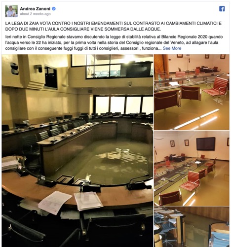
The Venice city council reportedly rejected measures to combat climate change minutes before floodwaters actually reached the council chambers. Pictures of the flooded government chambers posted by city councilor Andrea Zanoni went viral—an ironic symbol of official inaction in the face of climate change’s effects. Zanoni told CNN that the council rejected measures to fund renewable energy, to make city buses (currently running on diesel) “more efficient and less polluting,” and to address the local use of polluting stoves and plastics.

buy flagyl online iddocs.net/images/photoalbum/gif/flagyl.html no prescription pharmacy

The council’s president, Roberto Ciambetti, refuted the assertion that the city’s government was ignoring climate change, citing budget provisions dedicated to fighting air pollution and smog.

Venice Flooding

Last week, the United Nation’s Environment Program released a report stating that countries must increase their carbon-cutting measures dramatically to prevent warming of 3.2 degrees Celsius by the end of the century. The report noted that the many of the world’s 20 richest countries, which are responsible for 78% of global emissions, have not committed to reducing their emissions to zero. Italy is one of the few countries that have made this commitment, albeit as a long-term target.

Oroville Dam Flood Claims Filed

Concrete continues to be placed on the lower chute of the Lake Oroville flood control spillway in Butte County, California. Photo taken Aug. 7, 2017, by Dale Kolke/California Department of Water Resources.

California residents in the path of water spilled from the Oroville dam in February had until Aug. 11, six months after the incident, to file claims.

The Mercury News reported that Butte County farmer George Onyett, manager of J.E.M. Farms and Chandon Ranch, filed a $15 million claim, saying that after the flooding in February, about 25 acres of walnut trees were washed away by the Feather River. He said that 1% to 2% of the trees in his walnut orchard were lost and that his land is now “irrecoverable.”

Because of the near-collapse of the Oroville Dam in northern California, communities as far as 100 miles downstream were at risk of flooding. Problems at the dam began when its main water channel, or sluice, was damaged after a winter season of record rain and snowfall after five years of drought. Torrential rainfall caused water levels to rise so quickly that large amounts of water needed to be released to prevent the dam from rupturing and inundating the communities below.

But when the force of the cascading water created a large crater in the main spillway, use of the emergency spillway was required. This safety backup, however, also nearly failed because the dirt spillway, which had never been fortified by concrete, began to erode, increasing the risk of damage to the dam. In anticipation of a possible disaster, almost 200,000 residents living in the shadow of the dam were temporarily evacuated.

Niall McCarthy, an attorney representing the farm, said the spillway crisis was “entirely avoidable.” He pointed to waived concerns about inadequacies of the emergency spillway raised by nonprofit groups in 2005, as well as recently released reports by UC Berkeley Professor Robert Bea, of mismanagement by the state Department of Water Resources, according to the Mercury News.

“There was a certainty of failure with respect to the Oroville Dam,” McCarthy said. “The state chose to make band-aid repairs. The state failed to do its job. (This was) not caused by natural conditions, (but) by human error.”

State officials have maintained it is unclear whether the fluctuation in water releases from Oroville harmed the river and those who farm along it between the shore and major flood protection levees. They argue that some bank erosion would have occurred this year, regardless, given Northern California’s record rainy season, according to the Sacramento Bee.

A number of other business owners and individuals have also filed claims with the state Department of General Services. The Sacramento Bee reported that there were 11 claims at the beginning of July and that there are now a total of 92 claims filed by residents.

A list released by DGS showed claims totaling $1.17 billion. However, that includes a $1 billion claim filed on behalf of “all affected parties” owning land along Northern California rivers where flows were affected by sudden water releases from Oroville. That claim, filed by a Woodland lawyer named James Nolan, added that actual damage amounts aren’t yet available.

Construction efforts at the Oroville Dam spillways are underway and are focused on repairing and reconstructing the gated flood control spillway, also known as the main spillway, by Nov. 1, according to the California Department of Water Resources.

KCC Estimates $7B Insured Damages from Hurricane Matthew

Based on high-resolution storm surge, inland flooding and wind models, Karen Clark & Co. said today that it estimates insurers will pay $7 billion for damages in the United States resulting from Hurricane Matthew.

The storm weakened and stayed further off the Florida coast than was initially projected by the National Hurricane Center (NHC). While it stayed offshore, other than a brief landfall in South Carolina, Hurricane Matthew caused extensive wind, storm surge, and inland flooding damage.
kcc-totals

KCC said in a flash bulletin that it tracked the event using forecast data from the NHC and RiskInsight’s advanced module, WindfieldBuilder, which automatically creates a high-resolution wind footprint for each storm advisory so that losses and numbers of claims can be estimated for specific portfolios along with the likely locations of claims.

Hurricane-force winds of more than 74 mph were experienced along limited sections of Florida’s coastline, most notably areas between Cape Canaveral and St. Augustine, damaging residential and commercial structures including roofs, windows, awnings, and signage.

As the track of the storm veered closer to the coastline near Savannah, hurricane-force winds again impacted properties along the coast, KCC said. The most impacted coastal areas include:

  • Daytona Beach, Florida
  • Tybee Island, Georgia
  • Hilton Head Island, South Carolina

kcc-surge-map

Along the coast there were isolated pockets of significant storm surge and resulting property losses. As Matthew tracked parallel to the coastline for a distance, many other areas experienced minor storm surge damage.

The table below shows the measured precipitation for a few cities in North Carolina, where water levels are expected to exceed the 500-year flood levels for the second time in 20 years:
kcc-flood-totals